.png)
How GPS Machine Control Changed Everything for North Texas Contractors
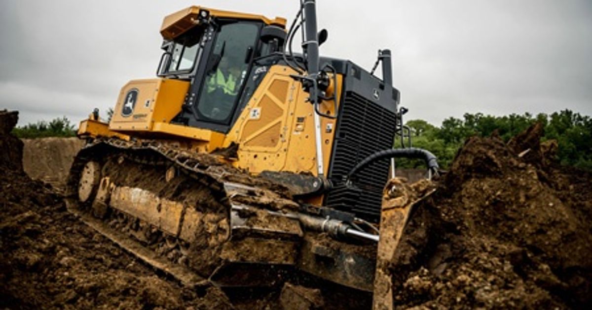
We watched a contractor grade a 40-acre Prosper development site last month using a John Deere 850L with smart grade GPS machine control. What typically takes two weeks with conventional grading methods got done in six days - with better accuracy than surveying stakes could provide. That's the power of GPS-integrated construction equipment, and it's becoming standard practice for smart contractors across North Texas.
GPS machine control systems transform how excavators, dozers, and graders operate by providing real-time positioning data accurate to within one inch. The technology guides operators through 3D digital models of the job site, automatically controlling blade height, bucket position, and cutting angles. Instead of relying on grade stakes and manual measurements, operators can see exactly where they are in the design and let the machine maintain perfect grade.
The Technology Behind GPS Machine Control Systems
Modern GPS machine control integrates four key components: satellite positioning, inertial measurement units (IMUs), hydraulic control valves, and cab display systems. The satellite receivers track machine position using signals from multiple GPS constellations, while IMUs monitor the machine's orientation and movement in real-time.
What makes this technology revolutionary is the hydraulic integration. Rather than just showing operators where to dig, the system automatically controls hydraulic functions to maintain design grade. When an excavator bucket approaches the target elevation, the system gradually reduces digging force and stops at the precise depth. Dozers automatically raise and lower blades to match design contours without operator input.
The Federal Highway Administration reports that 3D machine control can reduce project time by 25-50% while improving accuracy to sub-inch tolerances. We've seen similar results with contractors working on TxDOT projects throughout the Sherman-Denison corridor.
Real-World Applications in North Texas Construction
GPS machine control excels in applications where precision matters most. Site preparation for commercial developments in McKinney and Frisco requires exact elevations for proper drainage - something that's critical when dealing with expansive clay soils that move with moisture changes. The technology ensures consistent grade across large areas, preventing the low spots that cause water retention and foundation problems.
Utility trenching represents another major application. Most contractors rent our GPS-equipped excavators for 5-7 days when installing water lines or storm sewers in new Denton County subdivisions. The system maintains precise trench depth and slope, which becomes crucial when dealing with the caliche layers we typically encounter 4-6 feet down. Hitting grade the first time eliminates the costly rework that comes from trenches that are too shallow or have improper fall.
Road construction and reconstruction projects see massive efficiency gains. A contractor rebuilding Farm-to-Market roads near Gainesville told us the GPS dozer cut his fine grading time in half while eliminating the need for grade checkers. The machine automatically maintained crown and cross-slope specifications, something that's particularly valuable when working in summer heat where operator fatigue affects precision.
Equipment Types and GPS Integration Options
Most major manufacturers offer factory GPS integration, but the sophistication varies significantly. John Deere's system provides basic elevation control for dozers and motor graders, while their Grade with 3D system offers full machine automation using complete digital site models.
Excavators typically use indicate-only systems that show operators where to dig, or semi-automatic systems that prevent over-excavation. Full 3D systems control both boom and bucket hydraulics, automatically following complex slope profiles. The CAT 323 excavators in our Denton fleet run Trimble Earthworks systems that handle everything from simple trenching to complex pond grading.
Aftermarket systems from companies like Trimble, Leica, and Topcon can retrofit older machines, though integration varies. ASCE studies show that retrofitted systems deliver 70-80% of the benefits of factory integration at roughly half the cost, making them attractive for contractors testing the technology.
Operational Benefits Beyond Speed and Accuracy
The most immediate benefit contractors notice is reduced surveying costs. Traditional grade control requires surveyors to establish reference points and check progress throughout construction. GPS systems eliminate most surveying after initial site setup, saving $200-500 per day on typical projects. For larger developments in Celina and Aubrey, that surveying cost savings often covers the GPS equipment rental premium.
Fuel efficiency improves significantly with GPS control. Machines work more efficiently when following optimal paths and avoiding over-excavation. We track fuel consumption across our rental fleet, and GPS-equipped machines typically use 15-20% less fuel than conventional units performing similar work. In summer months when our 320 excavators run 10-12 hours daily, that fuel savings adds up quickly.
Material waste reduction delivers another major cost benefit. Precise grade control eliminates the over-excavation that leads to excess hauling and backfill requirements. A contractor building retention ponds for a Trophy Club development calculated that GPS control saved 400 cubic yards of unnecessary excavation - worth $8,000 in avoided hauling costs.
The Occupational Safety and Health Administration recognizes that GPS systems can improve job site safety by reducing the need for ground personnel near operating equipment. Grade checkers and surveyors spend less time in active work zones, while operators maintain better situational awareness through integrated displays.
Challenges and Learning Curve Considerations
The biggest challenge contractors face is the initial learning curve. Operators accustomed to conventional methods need training to interpret GPS displays and trust automated systems. Most of our customers request operator training when renting GPS-equipped machines for the first time. The investment pays off quickly - operators typically become proficient within 2-3 days of hands-on use.
Site conditions can affect GPS performance. Dense tree cover blocks satellite signals, while tall buildings create reflection issues in urban areas. Most Denton and Fort Worth construction sites provide adequate satellite visibility, but contractors working in heavily wooded areas near Wichita Falls sometimes need backup grade control methods.
Initial setup requires accurate digital site models, typically created from surveying data or drone mapping. The quality of these 3D models directly affects system performance. We've seen projects delayed when contractors attempt to use outdated or inaccurate design files. The Associated General Contractors recommends investing in professional 3D modeling to maximize GPS system benefits.
Cost Analysis: When GPS Control Makes Financial Sense
GPS-equipped machines typically rent for $100-200 per day more than conventional units, but the productivity gains usually justify the premium on projects larger than half an acre. The break-even point depends on job complexity and accuracy requirements. Simple mass excavation might not benefit as much as precise utility installation or finish grading work.
We've tracked rental patterns across hundreds of North Texas projects. Contractors typically see positive ROI when GPS control eliminates surveying costs, reduces rework, or accelerates project completion. A Mansfield contractor calculated that GPS control on a 20-acre site development saved three days of schedule time worth $3,600 in avoided overhead costs, easily covering the $800 rental premium.
The technology becomes increasingly valuable as labor costs rise and skilled operators become harder to find. GPS systems allow less experienced operators to achieve precision that previously required years of experience. For contractors struggling to find qualified operators, the technology can bridge skill gaps while maintaining quality standards.
Future Developments in GPS Machine Control
Machine learning integration represents the next evolution in GPS control technology. Systems are beginning to learn from operator behavior and site conditions to optimize performance automatically. Advanced systems can predict ground conditions based on excavation resistance and adjust cutting patterns accordingly.
Multi-machine coordination is emerging for large projects. Systems can coordinate multiple machines working in the same area, preventing conflicts and optimizing workflow. NIST research suggests that connected machine systems could improve large project efficiency by another 20-30% beyond individual machine benefits.
Augmented reality displays are being integrated with GPS systems to provide even more intuitive operator interfaces. Instead of interpreting 2D displays, operators can see grade information overlaid directly on their view of the work area. Several manufacturers are testing these systems for commercial release within the next two years.
Getting Started with GPS Machine Control
The best approach for contractors new to GPS technology is starting with a rental on a suitable project. Choose work that requires precision - finish grading, utility trenching, or pond construction - rather than simple mass excavation. This allows you to experience the benefits without the full equipment purchase commitment.
Proper site preparation maximizes GPS system effectiveness. Ensure accurate base point setup and verify that 3D design files match actual survey data. Most problems we see with first-time GPS users stem from setup issues rather than equipment limitations. Taking time for proper calibration prevents frustrating delays once work begins.
Operator training should focus on understanding system displays and trusting automated functions. Experienced operators often struggle with letting the machine control grade automatically. We recommend starting with indicate-only modes before progressing to full automation as operators build confidence in the technology.
Planning your next precision grading project in the Denton County area? We keep GPS-equipped excavators and dozers ready for immediate deployment throughout North Texas. The productivity gains typically pay for the rental premium within the first few days, especially when you factor in reduced surveying costs and eliminated rework. Call us at (817) 403-4334 to discuss which GPS system configuration makes sense for your specific site conditions and timeline. Our team has supported GPS projects from small Argyle subdivisions to major Irving commercial developments - we can walk you through what actually works in North Texas clay and caliche.